Course Overview:
This course is designed for individuals with a background in
Geographic Information Systems (GIS) who are looking to deepen
their knowledge and enhance their skills in this field.
Course Objectives:
– Enhance participants’ understanding of advanced concepts and
techniques in GIS.
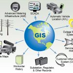
– Develop skills in spatial analysis and geographic modeling of data.
– Learn to use advanced tools and techniques in geographic
programming and spatial analysis.
– Apply advanced concepts to solve real-world problems in various
fields such as urban planning and natural resource management.
Training Content:
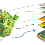
– Advanced spatial analysis.
– Advanced geographic modeling techniques.
– Geographic programming using languages like Python in
environments such as ArcGIS or QGIS.
– Applications of big data geographic analytics.
– Use of remote sensing and satellite imagery in advanced GIS
analyses.
Target Audience:
– GIS professionals seeking to advance their skills.
– Civil engineers, architects, and urban planners.
– Researchers in environmental sciences and natural resources.
– GIS information managers in government and private sectors.